

p4ges - Can Paying 4 Global Ecosystem Services reduce poverty?
p4ges invites regional stakeholders to learn about their hydrological field work
 |
 |
 |
 |
 |
 |
 |
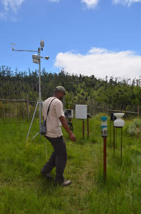
The p4ges project (can paying 4 global ecosystem services reduce poverty?) are doing field work in the eastern rainforests of Madagascar (the Corridor Ankeniheny Zahamena) to explore a full range of ecosystem services with local and global value, and the way in which land management influences the supply of these services. The hydrological team (a collaboration between the University of Zurich [UZH), the University of Twente [ITC], the Vrije Univesiteit Amsterdam [VUA], the University of Antananarivo Laboratoire des Radio-isotopes [LRI] and Kings College London [KCL]), are looking at how hydrological services are influenced by deforestation or forest restoration. They have installed some fairly complex equipment to intensively study three plots with different land use histories. They work in close collaboration with the Association Mitsinjo, a community-based organisation.
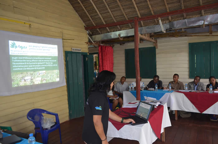
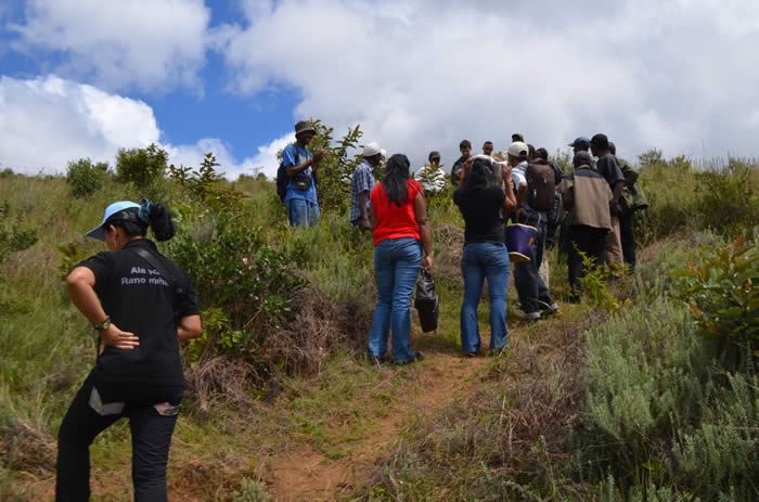
As an ESPA-funded project, p4ges is very concerned with ensuring its research has impact. To ensure the results can be used, it is vital to ensure that they are understood by those with the power to make decisions about land use. To this end, we invited regional stakeholders to visit the hydrology team in the field, to see the instrumented sites, to hear the preliminary results, and to ask questions directly to the researchers about this and the wider project. A total of thirty people attended the VIP day, including representatives of Madagascar National Parks, the Ministry of Agriculture, the Ministry of Environment, Ecology, Sea and Forests, the local mayor, representatives of the local community association and researchers from the University of Antananarivo and partner organisations.
Just before 9am, the conference space of Mitsinjo was well decorated and everything was prepared and ready to host the audience. Meanwhile, the hydro team had already prepared the equipment at one of the instrumented sites-one with heavily degraded soils after intensive land use post-deforestation. Around 9h30 all the visitors arrived and Youssouf, the vice-President of Mitsinjo kicked-off with a word of welcome. Nasoavina, the former President of Mitsinjo, continued with a word of thanks to the project and the presence of the audience. Before everybody introduced themselves, the Vice-Mayor of Andasibe told us about the importance of the water in our life and emphasized how lucky his commune is to have a project like p4ges, unique in its kind, within their area.
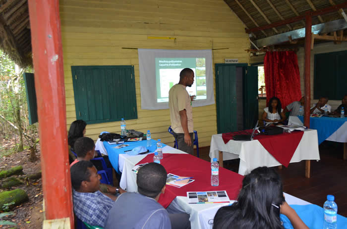
Dr Luciano Andriamaro (head of science at Conservation International and a key member of the p4ges team) gave an overview about the p4ges project; which institutions are involved, what the different teams are working on and how it all fits together to deliver the project’s overall aim. Maafaka Ravelona (a forester working with the hydrology team based in the Laboratoire des Radio-isotopes) continued with a presentation about the hydrology team’s work. He started with the current understanding of the links between water and land use, and the socio-economic context at the local and regional level as well. He then explained the research p4ges are doing in the area to explore the relationship between human activities, land use, stream flow and ultimately livelihood in terms of yield or crop production. To give the audience an idea of field hydrology, Maafaka explained the different pathways water can take from precipitation to discharge via streams (overland flow, subsurface flow or deep groundwater flow). With this knowledge in mind, Maafaka explained the key questions of the hydrology work package:
1. How does land use affect infiltration, soil structure, preferential flow?
2. What fraction of rainfall results in overland flow and subsurface flow under different land uses?
3. How does evapotranspiration (transpiration, interception) differ for a forest, a tree fallow and a degraded (tany maty) site? and
4. How is the streamflow response during rainfall events and the dry season affected by land use?
The visitors were given a leaflet explaining the research and including some preliminary results.
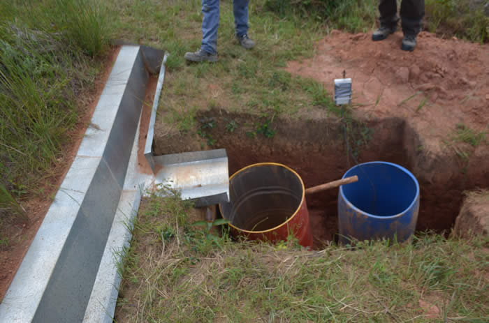
So far, the preliminary results show that for the clayey soil in the Andasibe area the infiltration capacity is largest for closed canopy and smallest for degraded land. This means that water flows most easily and quickly into the soil in the forest sites and least quickly into the soil in the degraded site. Measurements (in tree fallow and closed canopy) showed that approximately 10% of the rain is intercepted by the canopy (leaves and branches); that means that not all the rain reaches the soil surface. Furthermore, surface runoff is highest for the degraded land and lower for the tree fallow and forest sites.
The presentation ended with a short discussion about the opportunities and challenges on how to communicate the results to the Government, stakeholders and especially to the local community. The way of applying the results of the project, with or without PES scheme, was particularly emphasized. In other words: How to improve the living conditions of the local people in a sustainable way with the knowledge gathered by the p4ges project?
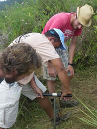
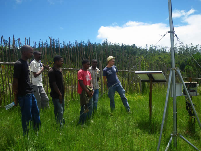
Before we headed to the field site, the VIP’s got some coffee and a snack to increase their sugar level to climb the steep hill to the field. When they arrived in the field, the VIP’s split up two groups. The first group attended the demonstration of Jaona (LRI), Pepijn (VUA), and Nanne (VUA) about the infiltration and soil measurements and related analysis. The other group visited the meteo station and runoff plots with Maafaka (LRI) and Bob (UZH). During these demonstrations, more detailed explanations were given about the measurements, the data, and general hydrological processes. The VIP’s were very interested. They were curious as well, what led to discussions, for example about why we choose a site or why are we measuring meteorological parameters at three different locations.
Nasoavina (former president of local environmental association Mitsinjo) noted “Thank you so much for explaining us what you do in this area. It is very important and our wish is that the final report of this project won’t just fill the scientific shelves but will be communicated to the local people and have a real sustainable impact on their livelihood, indeed for poverty alleviation”.
Another VIP said: “Thanks for giving us some scientific evidences about the affects of the land uses on the streamflow. Please put effort in spreading this to the people around here”.
Toutoun (Secretary and responsible of the environmental education in Mitsinjo): “Thanks for the presentation, I can see that the complicated research that you are carrying out can be explained in a simple way to the kids in primary school and emphasize the bad and good effects of the land uses on the stream flow”.
After the field visit all the VIP’s went to Mitsinjo where we had a nice meal “chicken sauce” before Nasoavina closed the event. On behalf of Mitsinjo, he gave a warm “thanks” to the project, including all the partners for taking this initiative and to the donors of this project. Furthermore he emphasized once more the importance of communicating the aim and results of the project to the local community. Finally he mentioned that Mitsinjo is already looking forward to the next showcase of the ESPA funded P4GES project. Following the success of this event, we are considering running a similar event for national-level stakeholders in September.
Thanks to all who helped facilitate the day, especially our hosts at Mitsinjo and colleagues from Conservation International and Laboratoire des Radio-Isotopes.
10 April 2015
Maafaka Ravelona and Bob Zwartendijk

p4ges - Can Paying 4 Global Ecosystem Services reduce poverty?
tel: +44 (0)1248 382650
email: info@p4ges.org
Copyright © 2015
Privacy and Cookies